|
|
|
|
Lorna and Sport, on the
first overlook. Silver Bay can be seen in the left background.
|
Lorna and Sport. Sorry
about the bad light metering on these shots.
|
|
|
|
|
Tony on the first overlook.
The trail loop was 6.4 miles from Penn Blvd. north of
Silver Bay. This was only 1.3 miles into it.
|
Penn Creek crossing. The
Lake Superior Hiking Trail Association knows how to build
really solid bridges.
|
|
|
|
|
|
|
|
Lorna on the Penn Creek
crossing bridge.
|
Tony on the Penn Creek
crossing bridge.
|
|
|
|
|
The lake access at Bean
Lake. It is a designated Trout Lake, stocked by the DNR.
|
Bean Lake, right after
lunch.
|
|
|
|
|
Lorna and Tony at the Bean
Lake overlook. The wind at the top took care of the mosquitoes.
|
The north-facing cliff
behind is about 200+ sheer vertical feet, and exactly
307 feet total down to the lake. Bean Lake is at 1193
feet of elevation.
|
|
|
|
|
The vertical wall looks
pretty sketchy for any rock climbing. Very loose and lichen-filled.
|
|
|
|
|
|
A nice "edge"
view...
|
Way off to the horizon,
at about 11 o'clock, is a gravel pit that is partially
flooded. It looks like a salt flat.
|
|
|
|
|
Lorna and Sport. Lorna
is the one on the right.
|
Another nice view of
the edge at Bean Lake.
|
|
|
|
|
The scree rock next to
the edge is scary enough to make you be pretty careful.
|
Another nice view of
the edge at Bean Lake.
|
|
|
|
|
Bean Lake cliff.
|
Lorna above Bear Lake,
just east of Bean Lake.
|
|
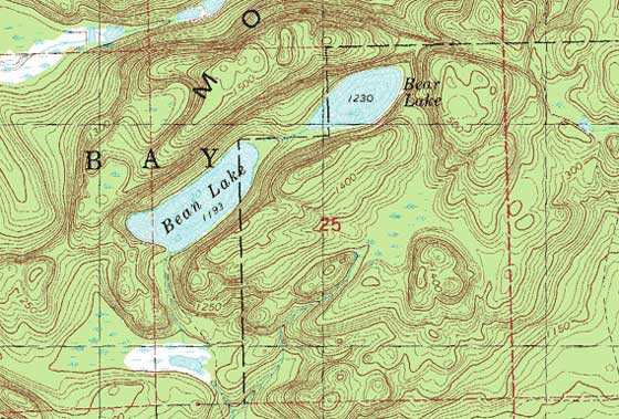
USGS Topographical
Map of the Bean and Bear Lake Area
Note the rapid elevation lines
near the lakes? Very nice!
|
 |